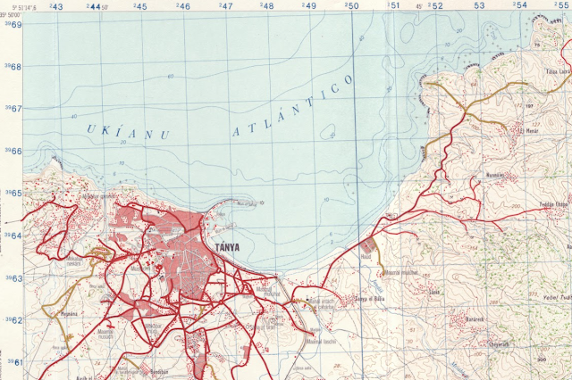
Discover topographic maps of Northern Morocco from the Spanish colonization, offering valuable historical and geographical insights. Download for free
Discover a unique collection of topographic maps of Northern Morocco, crafted during the Spanish colonization. These maps offer an in-depth representation of Morocco's northern regions, providing historical insights and detailed geographical features. Whether you're a researcher, historian, or geography enthusiast, these maps serve as a valuable resource for understanding the colonial-era geography of Morocco. Below, you’ll find a list of the notable locations covered by these maps:
Download the Topographic Maps
You can download the other 1:50,000 topographic maps in French.
These maps, created with remarkable precision, provide valuable insights into the terrain, rivers, mountains, and settlement patterns in the region. Al Hoceima, Tetouan, and Chaouen, as well as important coastal regions like Cap de l'eau and Ras Espartel, are particularly significant due to their historical and geographical importance during the colonial period.
Why Download These Maps?
- Historical Importance: Gain a glimpse into how Northern Morocco was mapped during the colonial era.
- Geographic Detail: These maps include key geographic details like rivers, mountains, and old transportation routes.
- Educational Resource: They are useful for research, educational purposes, or historical comparison with modern maps.
In summary, this collection of topographic maps of Northern Morocco offers a rare and invaluable perspective on the region's geography during the Spanish colonization. These meticulously crafted maps are not only a historical record but also a detailed geographic resource for researchers, educators, and geography enthusiasts. By downloading and exploring these maps, users can gain a deeper understanding of the landscape, settlement patterns, and natural features that have shaped Northern Morocco's past and continue to influence its present. Whether for academic research, personal interest, or educational use, these maps stand as a testament to the importance of preserving and understanding the geography of a region through time.


